Havana: Difference between revisions
| (16 intermediate revisions by the same user not shown) | |||
| Line 5: | Line 5: | ||
|Location = 23N 82W | |Location = 23N 82W | ||
|Level = 11 | |Level = 11 | ||
|Population = 27,000 | |Population = 27,000 (+1) | ||
|Forts = | |Forts = 6 | ||
|Commodities = NA | |Commodities = NA | ||
|Merch = -10 | |Merch = -10 | ||
| Line 14: | Line 14: | ||
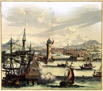
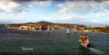
<p>The city of Havana was founded by the Spanish in the 16th century, it served as a springboard for the Spanish conquest of the Americas, becoming a stopping point for Spanish galleons returning to Spain. Philip II of Spain granted Havana the title of capital in 1592. Walls as well as forts were built to protect the city. Havana is one of the oldest cities in Cuba and the Caribbean altogether. The last stop for the Spanish treasure fleet before setting sail for Spain, Havana enjoys strong military protection, and its merchants a solid trade with Europe as any ships sail northeast with the treasure fleet.</p> | <p>The city of Havana was founded by the Spanish in the 16th century, it served as a springboard for the Spanish conquest of the Americas, becoming a stopping point for Spanish galleons returning to Spain. Philip II of Spain granted Havana the title of capital in 1592. Walls as well as forts were built to protect the city. Havana is one of the oldest cities in Cuba and the Caribbean altogether. The last stop for the Spanish treasure fleet before setting sail for Spain, Havana enjoys strong military protection, and its merchants a solid trade with Europe as any ships sail northeast with the treasure fleet.</p> | ||
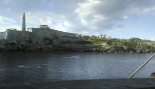
<p>Havana lies on the northern coast of Cuba along the Straits of Florida, south of the Florida Keys, where the Gulf of Mexico joins the Atlantic Ocean. The city extends mostly westward and southward from the bay, which is entered through a narrow inlet and which divides into three main harbors: Marimelena, Guanabacoa, and Atarés. The Almendares River traverses the city from south to north, entering the Straits of Florida a few miles west of the bay. There are low hills on which the city lies rise gently from the waters of the straits. A noteworthy elevation is the 200-foot-high (60-meter) limestone ridge that slopes up from the east and culminates in the heights of La Cabaña and El Morro, the sites of Spanish fortifications overlooking the eastern bay. Another notable rise is the hill to the west that is occupied by the Castillo del Príncipe.</p> | <p>Havana lies on the northern coast of Cuba along the Straits of Florida, south of the Florida Keys, where the Gulf of Mexico joins the Atlantic Ocean. The city extends mostly westward and southward from the bay, which is entered through a narrow inlet and which divides into three main harbors: Marimelena, Guanabacoa, and Atarés. The Almendares River traverses the city from south to north, entering the Straits of Florida a few miles west of the bay. There are low hills on which the city lies rise gently from the waters of the straits. A noteworthy elevation is the 200-foot-high (60-meter) limestone ridge that slopes up from the east and culminates in the heights of La Cabaña and El Morro, the sites of Spanish fortifications overlooking the eastern bay. Another notable rise is the hill to the west that is occupied by the Castillo del Príncipe.</p> | ||
=Government= | |||
[https://en.wikipedia.org/wiki/Captaincy_General_of_Cuba Captaincy-General of Cuba]/Governorate of Havana (since 29 September 1724): [https://es.wikipedia.org/wiki/Dionisio_Mart%C3%ADnez_de_la_Vega Don Dionisio Martínez de la Vega] | |||
=Locations= | =Locations= | ||
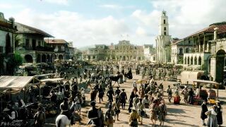
<p>Within Havana's city walls are its five large plazas, each with its own architectural character: </p> | <p>Within Havana's city walls are its five large plazas, each with its own architectural character: </p> | ||
*Plaza de Armas | *''Plaza de Armas'' | ||
*Plaza Vieja | *''Plaza Vieja'' | ||
*Plaza de San Francisco | *''Plaza de San Francisco'' | ||
*Plaza del Cristo | *''Plaza del Cristo'' | ||
*Plaza de la Catedral | *''Plaza de la Catedral'' | ||
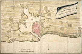
<p>Around these plazas are many outstanding buildings, including the Iglesia Catedral de La Habana, Antiguo Convento de San Francisco de Asís | <p>Around these plazas are many outstanding buildings, including the ''Iglesia Catedral de La Habana,'' and ''Antiguo Convento de San Francisco de Asís.'' Interspersed with this mix of baroque and neoclassical style monuments is a homogeneous ensemble of private houses with arcades, balconies, wrought-iron gates and internal courtyards. A complex system of fortifications protects Havana, its port and its dockyard:</p> | ||
*''Castillo de la Real Fuerza'' (''La Fuerza'') –one of the oldest colonial fortresses in the Americas (begun in 1558)– on the west side of the canal near the ''Plaza de Armas'' | |||
*''Castillo de San Salvador de la Punta'' (''La Punta'') guarding the entrance to the canal, on the west | |||
*''Castillo de los Tres Reyes del Morro'' (''Del Morro'') guarding the entrance to the canal, on the east | |||
*''Torreón de San Lázaro,'' a small round tower, a little down the coast to the west | |||
*''Torreón de la Chorrera'' (''Castillo de Santa Dorotea de Luna de la Chorrera'') stands on a coral islet only a few metres from the shore and not much larger than the tower itself, it's purpose being to impede the entry of enemy ships into the mouth of the Almendares River, far down the west coast. | |||
*''Reducto de Cojímar'' down the east coast, guarding the Cojimar river mouth | |||
=Timeline= | =Timeline= | ||
16-20 Feb 1725 | |||
*Arrived before noon on 16 Feb | |||
*[[William Rogers]] contacted the British spy network and, delivered the spy letter obtained at [[Port-de-Paix]] | |||
*[[William Rogers]] caught up to [[Pickford Rodney]] and learned the painter's last-known location | |||
*[[John Hayden]] confirmed [[Matthew Sumner]] had escaped prison there | |||
*[[John Hayden]] spoke to Capitaine [[Alain du Pré]] of ''[[Le Chasseur]]'' | |||
*[[Sir Randel Payne]] met [[Inara Muñoz|"Amira Mercedes de Luna"]] | |||
*[[Artegal Spenser]] encountered [[Damian Rush]] the second time; learned "cultists" had ransacked some local libraries there | |||
*Departed around noon on 20 Feb | |||
=Gallery= | =Gallery= | ||
Latest revision as of 20:14, 29 March 2023
| Havana, Cuba | ||||||||||||
 | ||||||||||||

|

See Wikipedia
The city of Havana was founded by the Spanish in the 16th century, it served as a springboard for the Spanish conquest of the Americas, becoming a stopping point for Spanish galleons returning to Spain. Philip II of Spain granted Havana the title of capital in 1592. Walls as well as forts were built to protect the city. Havana is one of the oldest cities in Cuba and the Caribbean altogether. The last stop for the Spanish treasure fleet before setting sail for Spain, Havana enjoys strong military protection, and its merchants a solid trade with Europe as any ships sail northeast with the treasure fleet.
Havana lies on the northern coast of Cuba along the Straits of Florida, south of the Florida Keys, where the Gulf of Mexico joins the Atlantic Ocean. The city extends mostly westward and southward from the bay, which is entered through a narrow inlet and which divides into three main harbors: Marimelena, Guanabacoa, and Atarés. The Almendares River traverses the city from south to north, entering the Straits of Florida a few miles west of the bay. There are low hills on which the city lies rise gently from the waters of the straits. A noteworthy elevation is the 200-foot-high (60-meter) limestone ridge that slopes up from the east and culminates in the heights of La Cabaña and El Morro, the sites of Spanish fortifications overlooking the eastern bay. Another notable rise is the hill to the west that is occupied by the Castillo del Príncipe.
Government
Captaincy-General of Cuba/Governorate of Havana (since 29 September 1724): Don Dionisio Martínez de la Vega
Locations
Within Havana's city walls are its five large plazas, each with its own architectural character:
- Plaza de Armas
- Plaza Vieja
- Plaza de San Francisco
- Plaza del Cristo
- Plaza de la Catedral
Around these plazas are many outstanding buildings, including the Iglesia Catedral de La Habana, and Antiguo Convento de San Francisco de Asís. Interspersed with this mix of baroque and neoclassical style monuments is a homogeneous ensemble of private houses with arcades, balconies, wrought-iron gates and internal courtyards. A complex system of fortifications protects Havana, its port and its dockyard:
- Castillo de la Real Fuerza (La Fuerza) –one of the oldest colonial fortresses in the Americas (begun in 1558)– on the west side of the canal near the Plaza de Armas
- Castillo de San Salvador de la Punta (La Punta) guarding the entrance to the canal, on the west
- Castillo de los Tres Reyes del Morro (Del Morro) guarding the entrance to the canal, on the east
- Torreón de San Lázaro, a small round tower, a little down the coast to the west
- Torreón de la Chorrera (Castillo de Santa Dorotea de Luna de la Chorrera) stands on a coral islet only a few metres from the shore and not much larger than the tower itself, it's purpose being to impede the entry of enemy ships into the mouth of the Almendares River, far down the west coast.
- Reducto de Cojímar down the east coast, guarding the Cojimar river mouth
Timeline
16-20 Feb 1725
- Arrived before noon on 16 Feb
- William Rogers contacted the British spy network and, delivered the spy letter obtained at Port-de-Paix
- William Rogers caught up to Pickford Rodney and learned the painter's last-known location
- John Hayden confirmed Matthew Sumner had escaped prison there
- John Hayden spoke to Capitaine Alain du Pré of Le Chasseur
- Sir Randel Payne met "Amira Mercedes de Luna"
- Artegal Spenser encountered Damian Rush the second time; learned "cultists" had ransacked some local libraries there
- Departed around noon on 20 Feb
Gallery
-
 Harbour Chart
 -
-
-
-